please note that I am currently remaking my homepage . As I have lots of other things to do and want to make all more relaxed, this may take years. At least I foremost will try
regularly to provide my weatherforecast and this page REPORTING BOUT SEPS SOLAR PROTON EVENTS; those have strong effects on the earth and menkind.
be patient ... this page contains much data and will need some time to load!
20201210: More and more sunspots become again visible on the solar surface The next 11 year sunspot maximum is expectet for 2022- 23. Time to resume observation. please be patient until January 2021, when this page will appear in a new shape
click here for the links list of archived previous monthly reports (back to 2010)
ARCHIVED REPORTS OF MY SOLAR TERRESTRIAL BLOG
2018 >
2017>
2016 >
2015 >
2014 >
2013 >
2012 >
2011 >
2010 >
remark: 2010 has no monthly archives but 1 archive of the entire year-
LAST MAXIMUM ACTIVITY IN: 2012/ 13 NEXT: APPR. in 2024
SOLAR AND TERRESTRIAL BLOG
Archive 2022
SPECIAL REPORTS ON SOLAR PARTICLE EVENTS
(proton emissions and subsequent electron accumulations and their geophysical effects)
reports about hot spot volcanism, earthquakes,geomagnetic field , natural and technical events, paradox weather, anomalies a.s.o)
Note this report will only contain SIGNIFICANT Events as described below ! For general information and daily updates on solar activities and related issuesw select one of the links on the right frame
Pretty horrifying, not knowing if it’d actually stop after a full minute. Could feel the entire house shaking significantly - whole structure rocked back & forth - underneath my body, while crawling on my knees to try to get to a reasonably safe spot. First aftershock just hit now too (2:53 am)
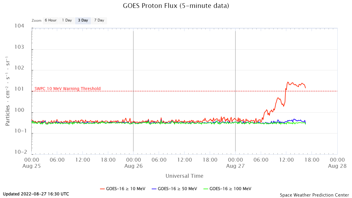
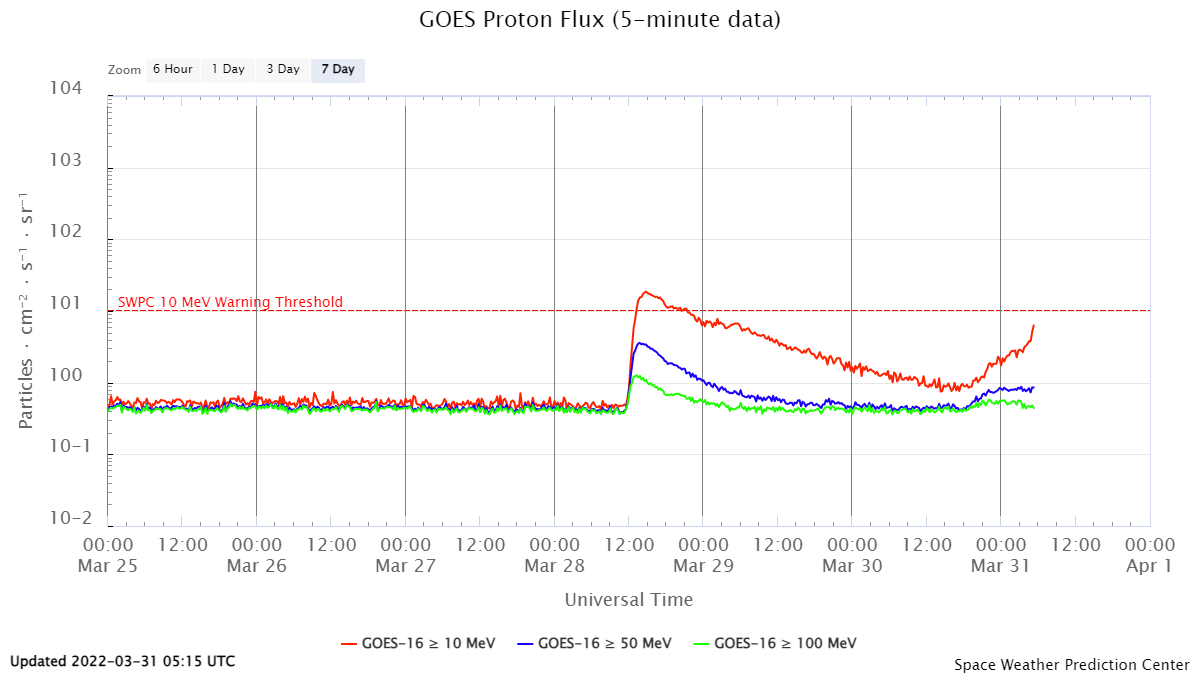
atommüllager sollten nicht in erbebengebieten errichteT werden. ..auch in eine schweiz ist ja schon lange nix mehr sicher.......mancherorts kommt mal ne felswand runter oder eine gletscherzunge bricht und rutscht ab. gerade kommt es zu einer ungewöhnlichen häufung der dort durchaus regelmäßigen aber eher seltene mikrobeben mit einer der wohl stärksten dort gemessenen Magnituden nahe basel . M 4.7 - FRANCE-GERMANY BORDER REGION - 2022-09-10 15:58:13 UTC::::::::::::::::::::::::::::::::::::::::::::::::::::::::::::::::::::::::::::::::::::::::::::::::::::::::::::2023 ist in etwa das Maximum des 11 jährigen Sonnenfleckenzyklus. das bringt gewöhnlich rekordernten nund warme winter. Währen die Anzahl der Sonnenflecken sich während der letzten maxima 2001 und 2012 von den wissenschaftlern sorgenvoll beobachtet- eher verringert hat ist die anzahl der protonenereigniss offenbar angestiegen und lag zwischen 2012 und 14 bei ca 140. wäre gut für das testprogramm der nasa doch leider kann es nicht starten oder man hat angst vor radio blackouts.................................................................................................................................................es ereignet sich nämlich gerade wieder ein noch ansteigender Protonensturm auf der Sonne der durchaus bis zu einer Woche dauern kann wonach es aber über dem norpol regelmäßig zu einer äquivalenten Elektronenakkumulation kommt so dass eine seps wirkungen haben kann die monate andauern . - diese sep folgt einer stärkeren sep vom 27.8 und akkumuliertsich damit als die zweite einer möglichen serie in welchen sich oft mehrere seps sich oft hintereinander ereignen bis sich der jeweilige sonnenfleck augelöst hat. . Man sieht also. es geht um große energiemengen wobei eine sep wirklich die bisher einzigec sonneneruption ist die erhebliche geophysikalische wirkungen hat (nasa they can do everything....................................................................................................................................................)typischerweise ereignen sich nach stärkeren seps oft schwere magmatischen schwere beben und ich sage nichts falsches wenn ich bzw lässt es sich belegen, dass die beiden seebeben seebodeneruptionen und tsunami am 26 12 2004 und am 11 3 2011 vor fukiushime während einer solchen serie solarer protonenereignisse staffanden.. https://www.swpc.noaa.gov/products/goes-proton-flux?fbclid=IwAR0xdsLi4qNbC9hwTgYC_0_4F-LQUnNT10K22ZHROtXYuiTGZOPFbBneesM
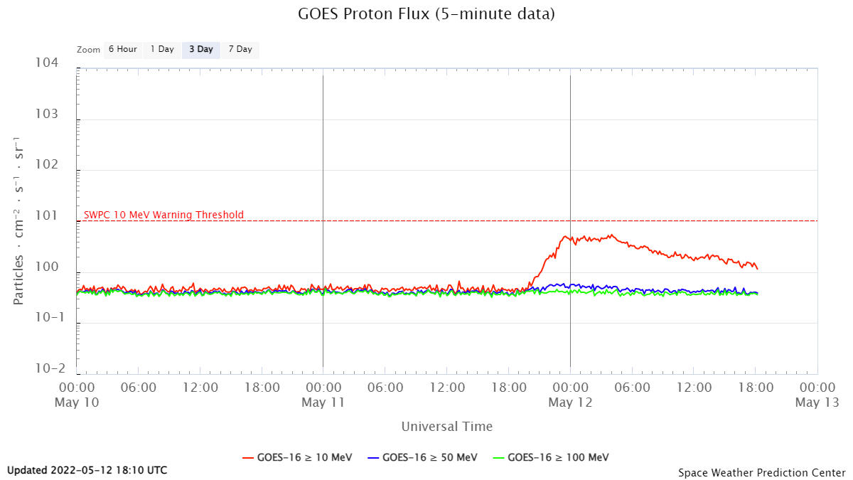
several large active regions have formed out on the solar disc. ar 13004 that has just rotated out at the western limp produced a LDE, CME, proton event, moderate type II radio sweep. s 7563 rotating in at the eastern limb attributed to AR 13007 by SWPC produced a stron flare even stronger early on may 11.
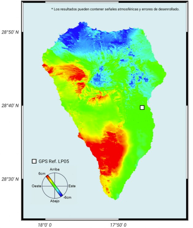
Am Vulkan auf La Palma ist die Inflation schnell gestiegen: die Bodenhebung beläuft sich nun auf bis zu 6 cm. Das geht aus einem Bericht vom IGN hervor. Gleichzeitig verlagerten sich die Beben in geringeren Tiefen und man geht davon aus, dass ein Magmatischer Gang bis in 8 km Tiefe vordrang. In den letzten 24 Stunden verringerte sich die Seismizität und es schaut so aus, als wäre der Magmenaufstieg (vorerst) gestoppt. Der Dyke steckt fest. Das heißt aber noch nicht, dass die Gefahr eines Vulkanausbruchs auf der Kanareninsel gestoppt ist. Für gewöhnlich folgen mehrere Phasen mit Inflation aufeinander, bevor es ein aufsteigender Magmenkörper schafft, bis zur Oberfläche durchzubrechen. Doch die Wahrscheinlichkeit, dass es bereits in den nächsten Tagen zu einer Eruption kommt, nimmt ab.
A powerful earthquake has struck the Caribbean nation of Haiti, killing at least 304 people and injuring more than 1,800. The 7.2-magnitude quake hit the west of the country on Saturday morning, toppling and damaging buildings including churches and hotels. The prime minister said there was "extensive damage" and declared a month-long state of emergency. Haiti is still recovering from a devastating 2010 earthquake. The epicentre of Saturday's quake was about 12km (7.5 miles) from the town of Saint-Louis du Sud, the US Geological Survey (USGS) said..
University of the West Indies Seismic Research Centre (UWI-SRC) and National Emergency Management Organisation (NEMO) reported that the lava dome in Soufrière St. Vincent’s main crater continued to slowly grow during 31 March-6 April, expanding to the N and S. Gas-and-steam continued to rise from the top of the dome, as well as along the contact with the pre-existing 1979 dome. A swarm of volcano-tectonic (VT) earthquakes began at 0638 on 5 April. The number and frequency of the VTs increased until about 0830 and then stabilized. The rate declined at around 1400 and then significantly dropped at 1600, though small VT events continued to be detected through 1800. The events were located at depths of 6 km, slightly deeper than the swarm events recorded during 22-25 March, located at revised depths of 3-5 km. Several reports of felt events came from nearby communities, including Fancy and Chateaubelair. The largest event, a M 3.5, was recorded at 0920 and felt by local residents. The swarm was more intense than the previous one, with an average rate of about 50 earthquakes per hour compared with 1.5 per hour during 22-25 March. The Alert Level remained at Orange (the second highest level on a four-color scale).
ALL SOLAR / TERRESTRIAL (NEAR TO) REAL TIME DATA AND PLOTS:
(2.0) ALL SOLAR / TERRESTRIAL (NEAR TO) REAL TIME DATA AND PLOTS:
HEAVY EARTHQUAKE FORECAST
update yourself!
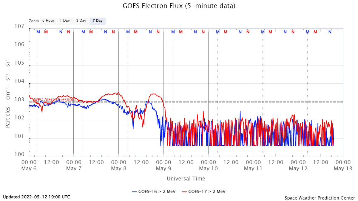
!if the integral electron flux / plot below) should SUDDENLY SHARPLY DROP, STRONGER MAJOR SUBDUCTION EARTHQUAKES become most probable! (globally!) You won`t believe that? Then test it!
Rising integral proton (= proton stotrm) = magmatic and hot spot intrusion with minor earthquakes
( see " NASA earth observatory / land surface temperature anomalies above). The temperature anomalies on the Northern hemisphere became more intensive in February 2015 , with Hudson Bayas in the past years still representing the coldest area and with temperatures in Sibiria in Russia exceeeding those in central and Southern Europe. Part of this anomalies are created by solar SEPs . But scientists also noted an increased shifting of the magnetic poles. Noting the last available report it seems however unlikely, that the Northern magnetic pole shifts towards Siberia as this official report claimed. Its rather likely or seems so, that it has already mainly shifted into Hudson |Bay * where we also have the relatively coldest region on the Northern hemisphere since years. The phenomenon of megnetic field shifting is known since the 60th and was since then observed by a group of american researchers,whonfirst came to the conclusion that the Northern magnetic field would move with expontial speeed/means first just some centimeters per year , than meters ...( but the official scientist still said, that those fluctuations would be quite normal
click here for all (INTERNAL) find all known volcanoes worldwide on my internal GLOBAL VOLCANO MAPS - including webcams and other features- click here to expand and close the collapsible panel -
CLICK HERE FOR INTERNATIONAL MEDIA AND NEWS SOURCES & OTHER EXTERNAL LINKS- DAILY NEWS FROM WHERE IT HAPPENS!..click here to expand and close the collapsible panel to read all..
NEWS CHANNELS:
( collecting of recommendable international news channels is still ongoing...): Note: This list is dedicated to get latest informations directly from regional news channels and sources all over the world . Alien-homepage does not take any responsibility for contents of websites posted on this list nor for their liability
The project startet as a documentary comparing and evaluating data of all typical sun spot features with geophysical events during the last 11 year sun spot cycly peaking in 2012- 14, using data images and measurements from the huge solar satellite based observation project the NASA had started at begin of this 24. observed solar sunspot cycle.
this huge research projct could not solve the basic questions about the phenomenon of sunspots and raised as always more question than those those cpoud be answered . At least it delivered what it should . solar and geophzsical data to establish a first space weather report necessary to protect high sensitive instruments built into satellites and airlanes as well as ground based ailway and electrivity networks (compare Carrington event.
posible effects on weather volcanism earthquakes activity were not part of the NASA mission, but became an interesting object for me, where bz the data provided by were very useful
You can find this documentary by clicking on erchives above.
Main objects of observation were>
solar flares
solar prominences and filament eruptions
coronal holes
solar particle events
To make it short After all , some theories about strong effects sunspot activities such as strong x class solar flares would have on the Earth turned out to be rather NECTLECTABLE RESP.MUCH weaker than expected , while others such as solar particle events * SPE could put the earth upside down. NASA first commented in a report called " a new type of solar eruption" a serial of proton events beginning on Nov 11 2004 with the last strong eruption in February 2005 with " they can do everything". The theories about them are rather poor, They had to delete that comment afterwards But meanwhile new satellites were put in place for better eobservations.
To give an example : Intensive comparation of stronger solar Proton events and earthquake volcanism data and reports showed there is a clear "coincidencc" ( a term that does not include or require further theories) between the two disastrous Tsunamis on 20041226 on Java as well as the 9.o magnitude earthquake and Tsunami near Fukushima Japan on 20110311. The deadly Tsunami 2004 near Java was likely caused by a strong magma intrusion from the Hot spot on java (Thomson Jule effect= that liftet the seaground up for 100o meters along a st5retch of 1000 km!!
At the end of the 24-. sun spot cycle this statistical ecvaluation and documentary had turned into a project that focusses on these Solar particle events ( Proton eruptions and subsequent electron accumulations)
research and documentary of the 24th solar cycle with evaluation of certain geoeffective Solar activities (esp. polarised rotating CMEs and SEPs) with coincident terrestrial events such as :
So first of all I want to explain, what this report is all about
1 What is a solar particle event?
(wikipedia)A solar particle event or solar proton event (SPE), or prompt proton event, occurs when particles (mostly protons) emitted by the Sun become accelerated either close to the Sun during a flare or in interplanetary space by coronal mass ejection shocks. The events can include other nuclei such as helium ions and HZE ions. These particles cause multiple effects. They can penetrate the Earth's magnetic field and cause ionization in the ionosphere. The effect is similar to auroral events, except that protons rather than electrons are involved. Energetic protons are a significant radiation hazard to spacecraft and astronauts.
what do we need to detect solar particle (proton) events?
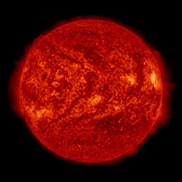
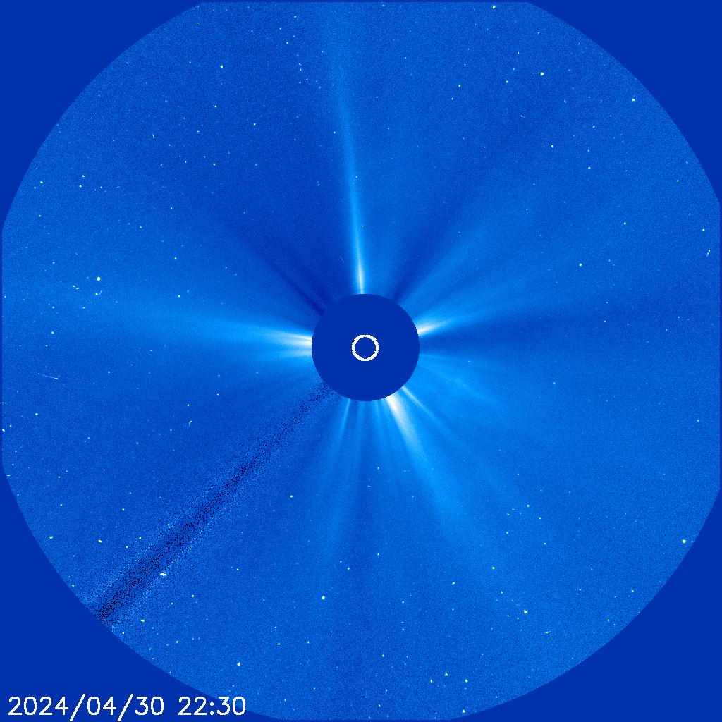
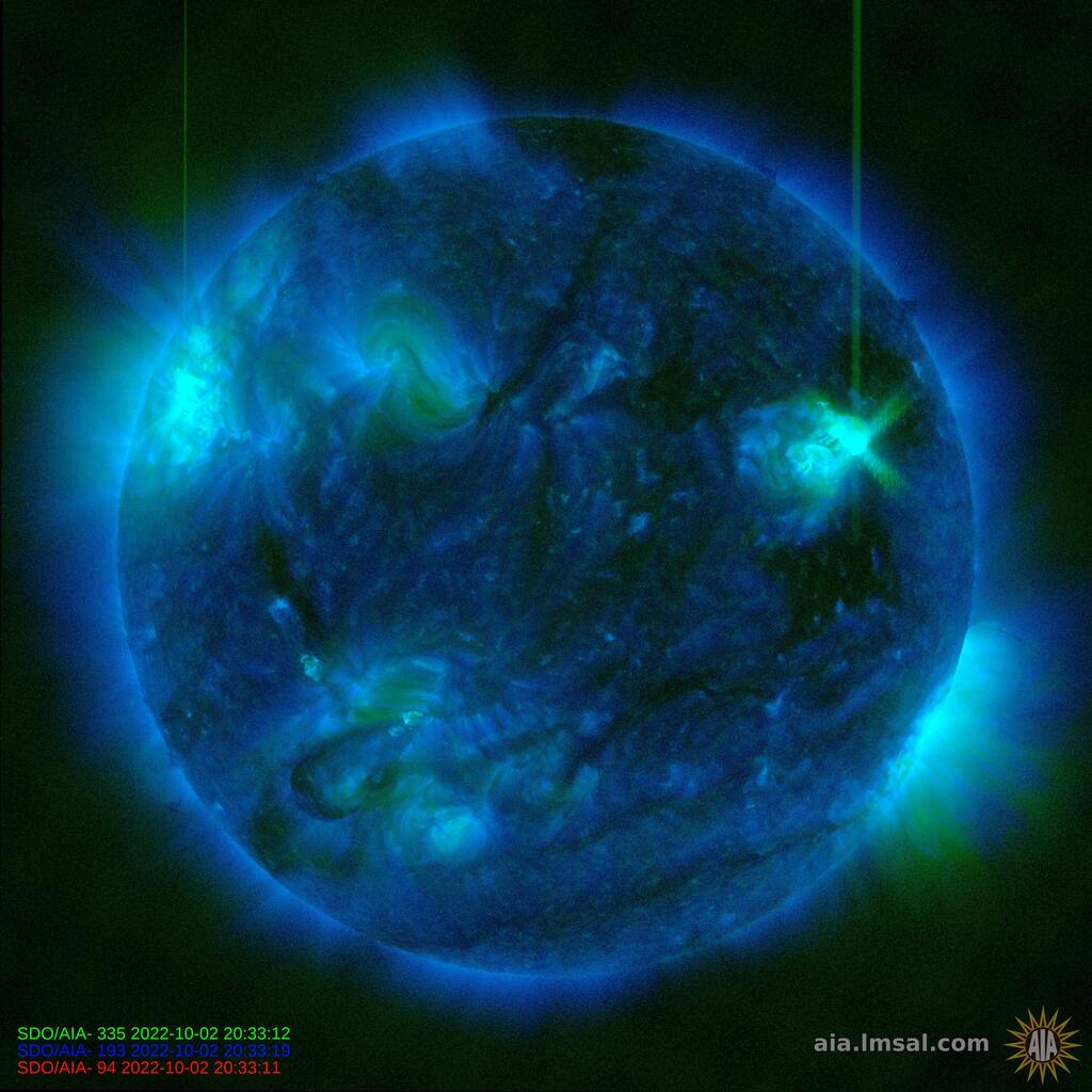
protons do not have electric energy and do not sprtead electrons or photons , Thus the protons events themselves v when on the occure on the sun are not visible within the frequency range of the most satellite teslecsopes images on board of SDO and SOHO. This is why Proton events are easily overseen.
What becomes visible on SOGHO and SDO images are the protons thrown into interplanetary space when they hit the objectives of telesscopes where they leave light traces or "snow" on the images
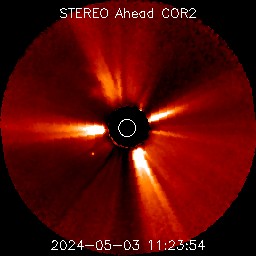
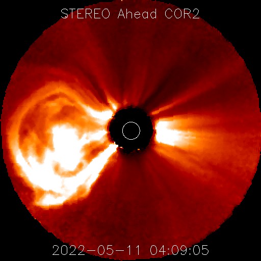
While STEREO BEHIND is dead since years , STEREO AHEAD still sends signals. It has with LASCO 2 as the only satellite also an infrared telescope that can show the the huge amounts of hot sun gazes accelerated by the proton explosion itself , that happens below the solar surface . The highly accelerated protons can reach the speed oF light and cause strong SECONDARY eruptions AND FLARES , while they penetrate the outer solar gas hull.
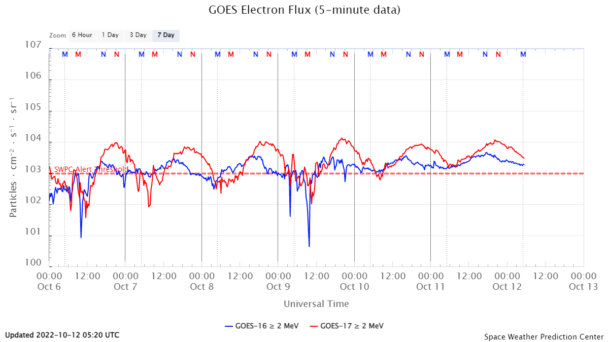
the other instruments are on the geostationary GOES 13 and 15 satellites those measure the integral proton flux into our geomagnetic field as well as the subsequent electron accumulation following each proton event:
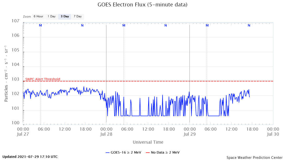


.png)