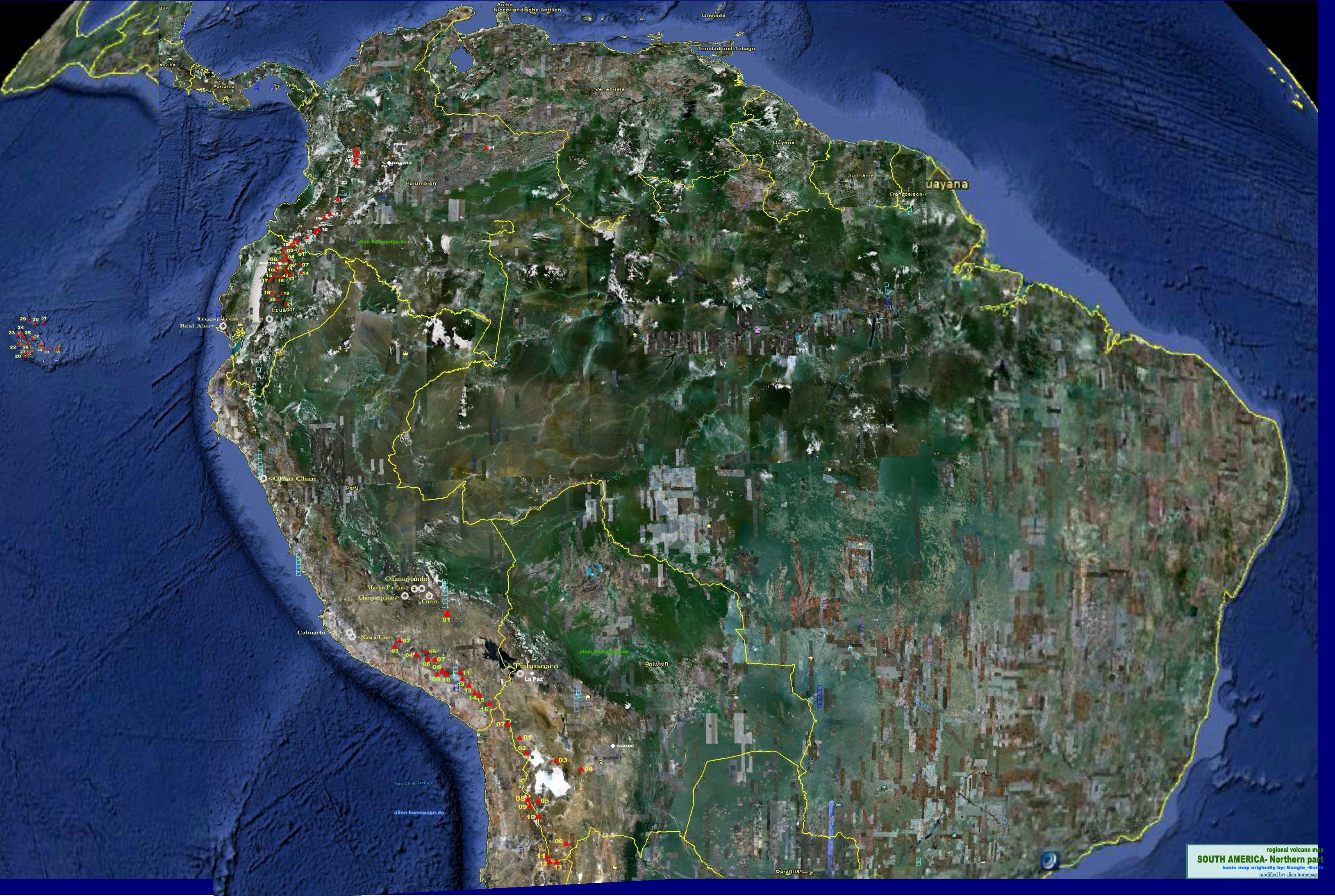
Index / ANCIENT SITES OF SOUTH AMERICA- NORTHERN PARTS
ancient sites of South America/ Northern Part
nr name and link to wikipedia country/ place geographical position
estimated age cultural reference literaric reference
short description internal links other sources
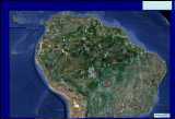
COLUMBIA:
Bogotá
Sierra Nevada de Santa Marta - " ciudad perdida" CO* 10° 52′ N/ 73° 43′ W unknown- rebuilt between the 11th and 16th century unknown, Tairona- Arhuaco , the Koguis and the Asario
Ciudad perdida
ECUADOR:
Quito
Chan Chan ECU 8° 6′ 30″ S/ 79° 4′ 30″ W 850 AD- 1300 AD Chimú
Moche civilization
Inca Empire
Chan Chan was once with 60.000 inhabitants the largest city on the South american continent. It was built around 850 AD by the Chimor. 1470 AD , it was conquered by the Inca empire, and soon later by the Spanish Conquista. Today Chan Chan is an archeological site and since 1986 added as an Unesco World Heritage Site
Ingapirca ECU 2° 32' S/ 78° 52' W unknown Cuzco By the Spanish Conquista named as the castillo.
Ingapirca is the most important Precolumbian archeological site of Ecuador. Similar to Machu Pichu or Cuzko, it is built out of great worked stones which fit in and stabilise another just by their shapes. As other ancient cities in Central and South America it has as well a Sun temple as Sun and Moon observatories and must therefore origin from the same culture and age. The main round building of the city was named by the spanish Conquista as "Castillo" . The real meaning of that building is not known yet.
ingapirca INGAPIRCA RUINS
Rumicucho Ruins
By pre Inca tribes called the city " real middle of the World"
Real Alto ECU
2.800- 2.400 BC Valdivia culture
Real Alto (Valvidia culture)
PERU:
National Geographics
Lima
Sechín Bajo PE* (GPS) 9.4647S/ 78.265W 2.000- 3.000 BC
SECHIN BAJA is probably one of the eldest ( or the eldest) ancients sites ever found in Colombia / Peru, dating back to 2- 3000 BC The complex mear to the river Sechin in the Casma valley was discovered 1992 by a German archeological team . Excavations are currently ongoing, but have already uncovered a complex of monumental buildings with a 100 meters high pyramide . Also interesting are ancient graffities . made in a similar drawing form as those found in nearby places showing scenes with larger and smaller people (photos etc.: see link ). Due to the archeologists website, a cathalogue is currently elaborated which will show all graffities found . Sechin Baja is nearby to another recently discovered site, the Sun observatory of Chankillo
Sechin Bajo Sechin Bajo
Chanquillo PE* 9° 33′ 24″ S, 78° 14′ 9″ W
Moche culture
Peruvian
Casma-Sechin
Chanquillo is a complex site in the Peruvian coastal desert, found in the Casma-Sechin Oasis ( best is to read the NASA article in the right column) The ruins include the hilltop Chankillo fort, the nearby Thirteen Towers solar observatory. The sun stands during each year`summer soltice beside the last tower at the one end and wanders until the winter soltice above the towers to the last tower on the other end of the installation. In my internal article about the Mesomerican calendars I tried to bring the periods of ( 2 times ) thirteen in a relation to the moon phases and the factor 27 as described as a part of the calendar system by Diego de Landa ( see: link second column on the right side)
Chankillo ( NASA)( internal) The Mesoamerican calendar Chankillo
CUSCO PE* 13° 31′ S, 71° 59′ W
Quechua World Heritage Site
in oldest times - long before the INCA , CUSCO was for the Chechuan Indians the place where the first men lived. . Cechua means "navel "Only the gods- t so they believe were older. 1.200 BC the city of Cucso was founded to honor these first men. Later, CUSCO became capital of the INCA Empire in the Andes. Today, CUSCO is an UNESCO World Heritage Site and widely known as the starting point to the ancient city of Machu Pichu
CUSCO
Machu Picchu PE* 13°09′47″S 72°32′44″W unknown Quechua
Pachacútec Yupanqui ( Inca)
World Heritage Site
ancient Inca city on the montain with the same name. As all cities of this perharpy most ancient civilisation period of South America Machu Picchu is made out of large granit stones which fit into another without any concrete . The site also contains typical cultural institutions such as a Sun and Moon temple and at least one observatory place. Much about MP is still unknown esp how the city was built, when and by whom exactly.
Machu Picchu
Nazca Lines PE* 14° 43′ 14″ S, 75° 9′ 1″ W unknown Nazca culture
Maria Reiche ,
designated as UNESCO World Heritage Site since 1994
The Nasca lines are since Eric v Däniken published his theories about extraterrist visits in the past , maybe one ofe the most discussed ancients sites on the world. Discovered by the Western archeologists in the 20th of the 20th century , the entire site covers a region of around 500 square kilometers with 8 great figures carved into the upper stone layer of the desert. those are only visible form an airplane reps. form a higher standpoint above. The site became world famous first by the work of the German Maria Reiche, who lived in N asca for more than thirty years until she died 1998 in Lima. The place contains also many other geometric forms straight lines and ramps with a length of up to 20 km. Meanwhile, many ancient ruins were excavated nearby to the lines. The understanding of the site does reach from a ritual place to a sports center up to a landing place of Ufos in ancient times ( Däniken) , where also possibly stone was won for several ancients sites around , whereby theses straight ramps where worked ionto the former mountains and hills .
Nazca lines
Cahuáchi PE 14° 49′ 8″ S, 75° 7′ 1″ W
Nazca culture
ancient site nearby to the Nasca lines with 6 step pyramids and 40 other buildings s, built out of clay bricks on an area of 25 square kilometer . Cahuáchi is regareded as the cultural center of the former Nasca culture.
Cahuáchi
Buena Vista PE* (GPS) 11.550 S/ 77.267 W
20 acre large archeological ancient place North of Lima, with the " temple of the Fox". The site is regarded as the eldest calendar of the world
The New World's Oldest Calendar Buena Vista
Choquequirao PE* 13° 23′ S, 72° 53′ W
Acient site in the South of Peru. particularly excavated- regarded as the " sister of machu Picchu"
Choquequirao
Ollantaytambo PE* 13° 15′ 14″ S, 72° 15′ 49″ W
Viracocha the English meaning of the name is " storage of my god"
ancient town in 2792 meters height in the southern Part of peru ( Cusco region). Due to an Indian legend, their god Viracocha has adviced the Inca to built the city. In the city are several large monoliths, Inca terraces, a temple and faces scarved into the rock. The city has strong walls against the mountains and might therefore have served well as a fortress to dominate the valley
Ollantaytambo
BOLIVIA:
SUCRE
Official capital of Bolivia
SUCRE
LA PAZ
administrative capital olf Bolivia
LA PAZ
TIAHUANACO BO* 16° 33′ 18″ S, 68° 40′ 25″ W unknown- first settlements around 1.500 BC Pre Inca
Inca
TIAHUANACO is situated in 4000 height in the region of Altiplano near to the Titicaca lake and close to Bolivias administrative capital La Paz.. When the Inca reached the region, they found the city already abandoned. The center of ancient site is a kind of great court yard with walls exactly matching the North/ South and East/ West direction , surounded by a straight wall out of large rectangled bricks stones with numerous stone head figures im between from those the most are weather worn yet. The o ther building are associated outside the rectangled wall and indicate the central court yard once had been the central place of the site. How the original building was like is unknown, Its installations adjusted the Sun Equanox is typical for the period of that unknown prehistorical culture , which has built the many other ancients sites such as Machu Picchu or Teotihuacan. The installations of stones to mark the Sun equanox and soltice is also similar to those found in Egypt.The building was at least once destroyed by an Earthquake. Nearby lies the Puma Punku place with many exactly worked monoliths - Allthough the archeologists obviously dont relate these stones to a former wall or roof , belonging to the courtyard , the ruins left look as if they could once even have been a huge rectangled palace from which just the entrance and the lower basement wall is left. This gate is around three meters high and 3,40 meters wide and made out of one stone with a weight of estimated 7- 12 tons. Archeologists call it the "Sun gate", as the Sun shines on a statue in the middle of the courtyard each Equanox and from am Eastern gate each winter soltice.. The straight standing statue with its mask like face in the centre of the yard on which the sun rays fall on the Sun events , represents some kind of god who wears like other statues on the place a hat or helmet ( whith a kind rayscarved on it) and has kind of runs on his robe or jacket
Templo de Kalasasaya TIAHUANACO
Index:
** about the Google Earth feature:
CO* = COLOMBIA ECU* = ECUADOR
PE* = PERU
READ ABOUT THE GOOGLE EARTH FEATURE: this column contains Google Earth program orders: click on one of the names and Google Earth will open and automatically navigate to the coordinates of that specific volcano on Google Earth! Google Earth programs tips: If google Earth does that too slowly, you can increase that" navigations speed" as follows: Use the menu on top of your Google Earth program window : There, open one after another the register cards for >" tools" > options > navigation. on the navigation card you find te controller for " apporach speed ( deutsch: Anflugsgeschwindigkeit) Just increase the approach speed there as intended. Possibly you have to close and reopen Google Earth afterwards, that these changes ind the function take place! NOTES: To use this "find with Google" feature, you must have installed Google Earth. There is no problem known: Nevertheless, the use of Google Earth as well as tzhe use of all feature on alien-homepage.de is on your own risk.
 more maintainance necessary . more than 100 links must be repaired- /last update. 20230524